One day history course in Yeoncheon looking toward the north in Gyeonggi-do Yeoncheon County · schedule Other · distance 92.3km · 7 stops · highlights G…
This is a day course in Yeoncheon where you can see the northern land. It is a fairly long course in Yeoncheon, known for its deep mountain terrain and slow development, but it is a rare course where you can experience unadorned nature as it is. Centered around a mountain called Gosan, meaning ancient mountain due to its deep valleys, you can look at historical traces including observation decks, a water tower remaining from the Japanese colonial period to the present, and the Jeongok-ri archaeological site.
This course is a sample one-day itinerary. Save it as-is or expand it into an AI itinerary.
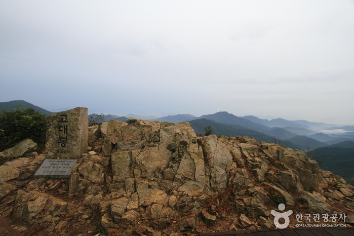
Godaesan (832m) is a mountain located on the border between Yeoncheon-gun, Gyeonggi-do, and Cheorwon-gun, Gangwon Special Self-Governing Province. Among mountains open for hiking, it is the closest to North Korea. From Godaebong, the summit of Godaesan, you can see the Cheorwon plain, Baengmagoji—a fierce battlefield during the Korean War—as well as North Korea’s Geumhak-san, Jijangbong, Bukdaesan, and Hyangrobong. Traditionally, Godaesan is considered one of Korea’s three sacred mountains (Samsinsan) associated with the legendary prophetic names Johwasin, Gyohwasin, and Chihwasin. The name Godaesan is also said to originate from “big whale,” linked to a new place name, referring to “banggorae” (a groove under the ondol heated floor where fire and smoke escape). Because Godaesan has deep valleys and is tall, it was named thus. Old maps also recorded it as Godae, meaning “like a high constellation.” The area around Godaesan was formerly known as Sintanmak, named for many taverns (jumak) established in villages amid abundant dense forests and rich forest resources suitable for producing timber and charcoal. Before the Korean War, the region was widely known for producing high-quality charcoal.
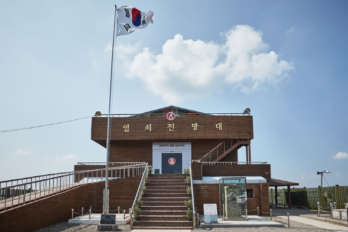
Yeolsoe Observatory was established on April 11, 1998, by the Army Yeolsoe Unit to provide security education and soothe the grievances of displaced persons. From the observatory, visitors can see the DMZ barbed wire fence and the frontline guard post (GP) at a glance. Inside the exhibition hall, North Korean household items and combat equipment against South Korea are displayed, offering a fragmented glimpse of North Korea's actual conditions. The exhibition hall also features a unification wish postcard tree shaped with barbed wire, adding interest for visitors.
천하무적 태풍부대에서 1991년 12월 3일 건립한 것으로, 서울에서 약 65km, 평양에서 약 140km 떨어진 중면 비끼산의 가장 높은 수리봉에 위치한다. 처음에는 군사분계선을 기점으로 2km 지점에 남방 한계선과 북방 한계선이 설정되었으나, 1968년 북한이 휴전선 가까이 철책을 설치함에 따라 우리나라도 1978년에 부분적으로 철책을 설치하였다. 태풍전망대는 휴전선까지 800m, 북한 초소까지는 1,600m의 거리에 떨어져 위치하고 155마일 휴전선상 북한과 가장 가까운 전망대로 유명하다.
한탄강 국민관광단지내 가장 규모가 크고 민물매운탕 맛이 뛰어나기로 소문난 곳이다.
The Yeoncheon Station Water Tower is a railway water tower built in 1919 at a midpoint between Incheon and Wonsan, used to supply water to steam locomotives. Steam locomotives and water towers first appeared with the opening of the Gyeongin Line between Seoul and Incheon in September 1899, serving as transportation means but disappeared with the advent of diesel locomotives in the 1950s. All historical facilities built in Yeoncheon during the Japanese colonial period were destroyed by bombing during the Korean War, but only the water tower remains well preserved in its original form. At the time of construction, during the water supply to the tender (炭水車) attached behind the locomotive, active trade took place, functioning somewhat like a marketplace. Until before the Korean War, this area was the southernmost region of North Korea, and a large amount of North Korean military supplies were unloaded via the Gyeongwon Line. Because of this, the white water tower served as a coordinate for intense air raids by U.S. forces, and shell marks are still clearly visible on the building. The Yeoncheon Station Water Tower, along with the water towers at Dogye Station in Gangwon-do, Chupungnyeong Station, Yeonsan Station in Chungnam, Andong Station in Gyeongbuk, Yeongcheon Station, and Samrangjin Station in Gyeongnam, is recognized as a significant heritage for understanding railway history and modern transportation research, designated as a national registered cultural heritage.
Jaein Waterfall has long been widely known as a scenic spot. The waterfall is formed where a small stream flowing down from Jijangbong in the north pours down an approximately 18m high basalt columnar joint cliff, creating a spectacular sight. Around Jaein Waterfall, it is also known as a habitat for natural monuments such as Eoreumchi and endangered species like the pink dragonfly. A beautiful love story related to the name of the waterfall has been passed down. Various basalt features can be observed at Jaein Waterfall, notably columnar joints, undercut caves, potholes, and gas tubes. The waterfall, about 18m high, continues to erode the area below it, forming a pothole with a depth of 5m. A pothole is a deep hole formed when whirlpools occur in concave or broken parts of river rocks.
The Jeongok-ri Site is located around the Hantan River in Jeongok-ri, Jeongok-eup, Yeoncheon-gun, and is a representative site of the early Paleolithic period in Korea. This site, a symbol of Korea's Paleolithic heritage, gained attention in 1977 when a U.S. soldier visiting the Hantan River recreational area discovered stone tools on the surface. The Jeongok-ri stratigraphy provides very important data for studying paleoclimate and paleoenvironment and is a geological landmark with records related to human development. In the clay layer, a soil wedge structure called soil wedge cracking phenomenon is observed, presumed to have formed in the Ice Age, and is an important resource for paleoclimate research. Additionally, volcanic ash (Tephra) carried by the wind from Japan was found in the stratigraphy, revealing that the upper layers were deposited about 20,000 to 100,000 years ago. Thus, the Jeongok-ri stratigraphy is archaeologically significant and is a crucial geological site for studying paleoclimate. (Source: Hantan River Geopark website)
Good places to stop and rest after the course

Booking and payment continue on a partner site.
Check rooms & price
Booking and payment continue on a partner site.
Check rooms & priceSign up to feature your channel.
(As a member, you can add your Instagram, YouTube, and blog links in My Page, and we’ll show them with every comment you write.)
““Stayed near Hongdae and did a night café tour. Perfect city views and vibes.””
Guest comments do not display social media links or profile cards.
Share a short tip about this place.
Or leave a quick comment as a guest.
Photo attachments are available after login.
No reviews yet. Be the first to share your experience!