Standing on Dokdo from Ulleungdo in Gyeongsangbuk-do Ulleung County · schedule Other · distance 39.4km · 4 stops · highlights Dokdo Observatory Cable Ca…
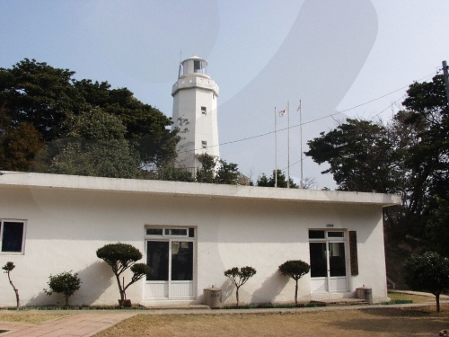
Starting point for the Ulleungdo journey, here you can follow the coastal cliff walking trails on the left and right sides of Dodong Port. Walking while looking at waves crashing against volcanic rock sea cliffs and the transparent seawater beneath the deep sea caves, end by standing at Haengnam Lighthouse, where colonies of autumn dandelion flowers bloom, and gaze out at the sea.
This course is a sample one-day itinerary. Save it as-is or expand it into an AI itinerary.
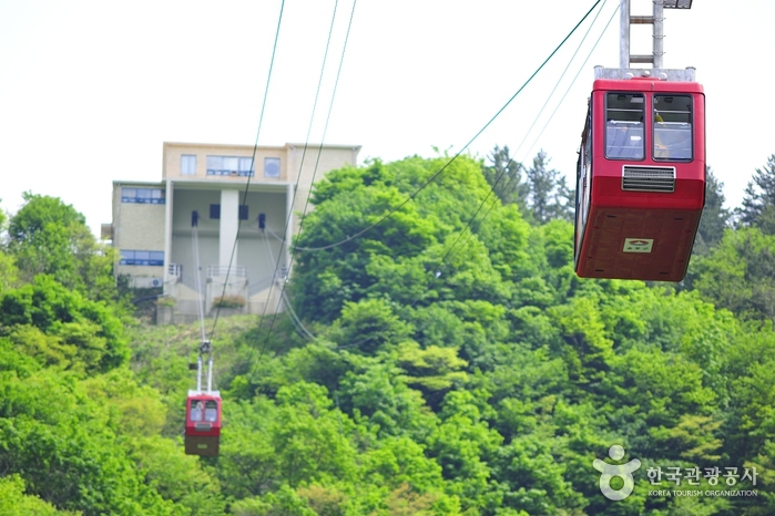
This cable car operates round-trip over a total length of 488m from Dodong Yaksu Park in Ulleungdo to the summit of Manghyangbong. It runs every hour on the hour at 15-minute intervals, taking about 5 minutes to reach the summit. From the Manghyangbong summit, you can see Dodong-ri and Sadong-ri in Ulleung-eup, Ulleung-gun at a glance, and on clear days, Dokdo can be observed with the naked eye. It is well known as a sunrise viewing spot, and at sunset, you can enjoy the sight of squid fishing boats, one of the eight scenic views of Ulleung.
등대가 위치한 행남마을은 도동과 저동 사이의 해안을 끼고 있는 촌락으로 울릉도에서 가장 동쪽에 위치하고 있다. 겨울에도 살구꽃을 볼 수 있다는 따뜻한 마을로, 마을 어귀에 큰 살구나무가 한 그루 있었다하여 행남(杏南)으로 전래되고 있다. 또한 지형이 뱀의 입처럼 생겼다고 하여 살구남(口南)이라고도 한다. 청명한 날에는 등탑에서 정동쪽으로 독도를 볼 수 있으며, 북쪽으로는 저동항의 아름다운 모습과 촛대바위를 한 눈에 바라다 볼 수 있고, 울릉도의 상징인 성인봉의 정상을 볼 수 있다.
Bongnae Waterfall consists of three tiers. From the top, the first tier is composed of granodiorite and tuff, while the second and third tiers are made up of agglomerate. The total drop is about 30 meters, with a flow rate exceeding 3,000 tons per day, serving as an important water source for the southern Ulleungdo area. The waterfall's uppermost part is made of granodiorite, which is more resistant to erosion than tuff or agglomerate. Differential erosion due to strength differences between the rocks has formed multiple tiers of the waterfall. As the lower tuff and agglomerate erode further, the upper granodiorite will collapse, causing the waterfall to retreat gradually. A walking trail leads from the Bongnae Waterfall management office to the waterfall, featuring a wind cave called the "natural air conditioner" due to the cold wind, a dam built to prevent landslide damage, and a forest bathing area for alleviating atopic dermatitis and relieving stress. Various plant species such as island hepaticas (large hepaticas), wasabi mustard, yellow Impatiens, large yanyeongcho, island male fern (umbrella male fern), and royal crown (royal crown root), as well as tree species including beech, umbrella gorosoe, cedar, akebia, mapojumeu tree (mapojumeu tree), and hinoki cypress can be seen, making it an excellent geological site for both geology and ecological education.
Nari Basin is a caldera crater formed by the collapse of a volcanic crater following the eruption of highly viscous trachyte, andesite, and tuff during the late Tertiary period of the Cenozoic era. In the past, people had no livestock and ate the roots of the island lily, which gave rise to the place name Nari, and thus it was called Nari Basin. Its size is about 1.5 km in east-west width, 2 km in north-south length, and the area is 1.5 to 2.0 km². The basin is surrounded like a folding screen by mountains about 500m in elevation, with the highest peak, Seonginbong (984m), located to the south, and inside the basin is the conical central crater, Albong (611m). Nari Basin’s landform was created by the collapse of a crater north of Seonginbong during a volcanic eruption, covering an area roughly equivalent to 28 soccer fields. Due to its unique volcanic terrain, it is registered as a national geosite park, and walking trails and trekking courses have been established around Nari Basin. The most recommended course is the trail around Albong (538m) and Gitdaebong (579m). Given the island’s characteristics, there are Ulleung daisies and plants unique to Ulleungdo, allowing visitors to enjoy a forest landscape unlike anywhere on the mainland.
Good places to stop and rest after the course

Booking and payment continue on a partner site.
Check rooms & price
Booking and payment continue on a partner site.
Check rooms & priceSign up to feature your channel.
(As a member, you can add your Instagram, YouTube, and blog links in My Page, and we’ll show them with every comment you write.)
““Stayed near Hongdae and did a night café tour. Perfect city views and vibes.””
Guest comments do not display social media links or profile cards.
Share a short tip about this place.
Or leave a quick comment as a guest.
Photo attachments are available after login.
No reviews yet. Be the first to share your experience!