Time Pauses in Nature While History Flows in Gangwon Special Self-Governing Province Cheorwon County · schedule Other · distance 41.3km · 4 stops · high…

This course introduces a slightly more special encounter with nature. Seoul Camping Site, located in Cheorwon Peace Village, is situated within the Civilian Control Zone. Togyo Reservoir, Goseokjeong National Tourist Site, and Sundam Valley tell stories where nature and history blend. Experience the mystery of nature by watching migratory birds flying in the sky and rivers flowing toward the sea, and create exciting moments through various hands-on programs.
This course is a sample 2-day itinerary. Save it as-is or expand it into an AI itinerary.
Togyo Reservoir was constructed by the government starting in 1972 and completed in 1976 after North Korea diverted the water flow of Bongrae Lake, an important water source of the Cheorwon Plain before the Korean War, to the Yeonbaek Plain of Hwanghae Province. With a maximum storage capacity of approximately 15 million tons, it is the largest man-made reservoir in Gangwon-do. The clear waters are home to a variety of fish species, and it serves as a migratory bird sanctuary where endangered species such as cranes and hooded cranes winter. Designated as one of the 8 views of Shincheorwon, it is located along the access road to the Second Tunnel, the center of Cheorwon security tourism, forming a beautiful lake landscape. In winter, it becomes a resting place for wintering migratory birds, and the spectacle of flocks of geese taking flight at dawn attracts birdwatching tourists.
2016년 5월 30일부터 오픈한 이 곳은 강원도 철원에 위치한 평화마을의 폐교에 만들어진 캠핑장이다. 이곳은 민간인 출입 제한 구역 내에 위치하고 있어 예약시 제한 사항을 꼼꼼하게 확인해야 한다.
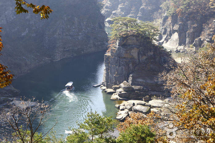
Goseokjeong is one of the nine scenic spots of Cheorwon and the most famous attraction in the area. Towering about 10 meters high in the middle of the Hantan River, a crystal-clear stream flows swirling between the two imposing rock formations. It is said that during the reign of King Jinpyeong of Silla, a two-story pavilion about 10 pyeong in size was built on the middle course of the Hantan River and named Goseokjeong. The pavilion and the valley around Goseok Rock together are called Goseokjeong. Designated as a local monument, it is said that King Jinpyeong of Silla and King Chungsuk of Goryeo visited and enjoyed this place. Goseokjeong became more famous as it was known as the base of Im Geokjeong during the Joseon Dynasty in the era of King Myeongjong. Cheorwon, formed by basalt lava flows in the Quaternary of the Cenozoic era, has the Hantan River flowing from north-northeast to south-southwest, creating columnar joints and vertical cliffs of granite through erosion. Located at the center of the Chugaryeong structural belt and later the passage of the Gyeongwon Line, Cheorwon was a suitable place for Im Geokjeong to hide, as he built a high stone wall opposite Goseokjeong as a mountain fortress base. He resisted the corrupt social class by intercepting tributes passing through this area to the royal court from Hamgyeong-do and aiding the poor. The pavilion was destroyed during the Korean War but was rebuilt in 1971 with local support as a 10-pyeong two-story structure; it was washed away by floods in 1996 and reconstructed again in 1997. Currently, a natural stone chamber where Im Geokjeong hid can be found in the massive 20-meter-high rock in the middle of the river, and a stone fortress remains on the opposite side. This scenic spot remains a national tourist site of Cheorwon’s nine views, attracting visitors year-round. About 2 km upstream are Jiktang Waterfall and about 2 km downstream is Sundam, with wide lawns and multipurpose sports grounds available, making it a favored destination throughout the seasons.
Sundam Valley, located on a tributary of the Hantan River in Galmal-eup, Cheorwon-gun, Gangwon-do, is known as the most beautiful valley featuring cliffs and columnar joints formed by volcanic activity along the Hantan River's flow. The name Sundam originates from the Joseon Dynasty period under King Jeongjo when Kim Gwanju dug a pond here and cultivated medicinal herbs for use. It is a U-shaped gorge formed by the erosion of the Hantan River, boasting uniquely shaped rocks, steep cliffs, and vertical waterfalls. A white sandy beach, rare along riverbanks, naturally formed due to the abundant water supply. The columnar joints are the valley's main attraction, consisting of horizontal faults formed by the Hantan River's erosion over hundreds of millions of years. The Hantan River Columnar Joint Trail, opened in 2021, is a 3.6 km course along the cliffs within the UNESCO-recognized Hantan River Geopark. Walking along the trail winding through the gorge provides views of the unique volcanic landforms around the Hantan River. Various bridges and observation decks enrich the scenic experience. Notably, from the Cheorwon Hantan River Sky Observatory, visitors can walk the glass trail while overlooking the spectacular Hantan River scenery. Dwitgang, ideal for rafting, is popular among rafting enthusiasts. Recently, its beautiful surroundings and gentle currents attract many beginners learning rafting on weekends. Many shops operated by professional instructors are available nearby for convenience.
Good places to stop and rest after the course

Booking and payment continue on a partner site.
Check rooms & price
Booking and payment continue on a partner site.
Check rooms & priceSign up to feature your channel.
(As a member, you can add your Instagram, YouTube, and blog links in My Page, and we’ll show them with every comment you write.)
““Stayed near Hongdae and did a night café tour. Perfect city views and vibes.””
Guest comments do not display social media links or profile cards.
Share a short tip about this place.
Or leave a quick comment as a guest.
Photo attachments are available after login.
No reviews yet. Be the first to share your experience!