在延川遇见高句丽 in 京畿道 延川郡 · schedule 其他 · distance 51.9km · 3 stops · highlights Godaesan, Dangposeong Fortress, Yeoncheon Horogoru
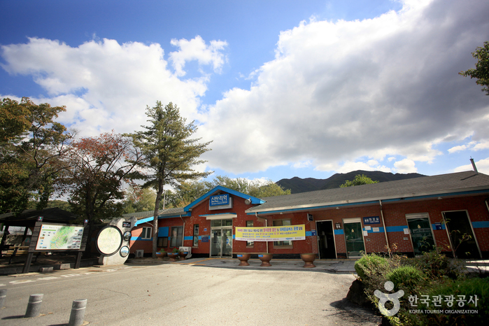
新炭里站在白马高地站开放之前,是京元线铁路的终点站。新炭里站周围有许多与“期盼统一的村庄”相关的景点,吸引了众多前往古代山的游客。延川的虎牢沟鲁城、银垈里城和唐浦城是南韩难得一见的高句丽遗址。高句丽曾控制至汉江,后退至临津江设立了防线。三处遗址在2000年代被发掘,仍是较为陌生的旅游地。
这条路线是单日行程示例。你可以直接保存,或扩展为 AI 行程。
Godaesan (832m) is a mountain located on the border between Yeoncheon-gun, Gyeonggi-do, and Cheorwon-gun, Gangwon Special Self-Governing Province. Among mountains open for hiking, it is the closest to North Korea. From Godaebong, the summit of Godaesan, you can see the Cheorwon plain, Baengmagoji—a fierce battlefield during the Korean War—as well as North Korea’s Geumhak-san, Jijangbong, Bukdaesan, and Hyangrobong. Traditionally, Godaesan is considered one of Korea’s three sacred mountains (Samsinsan) associated with the legendary prophetic names Johwasin, Gyohwasin, and Chihwasin. The name Godaesan is also said to originate from “big whale,” linked to a new place name, referring to “banggorae” (a groove under the ondol heated floor where fire and smoke escape). Because Godaesan has deep valleys and is tall, it was named thus. Old maps also recorded it as Godae, meaning “like a high constellation.” The area around Godaesan was formerly known as Sintanmak, named for many taverns (jumak) established in villages amid abundant dense forests and rich forest resources suitable for producing timber and charcoal. Before the Korean War, the region was widely known for producing high-quality charcoal.
Dangposeong Fortress maximized the use of terrain, building stone fortress walls only on the east side, connected by flat land without vertical cliffs. The east fortress wall is about 50m long and remains approximately 6m high, with a length of about 200m from the east wall to the west end of the fortress, and an overall circumference of about 450m. Most stones used for construction were processed local basalt, a major characteristic of Goguryeo fortresses. Behind Dangposeong Fortress lies Majeonhyeon, a route to Gaeseong, making the fortress essential for defending against northern enemies approaching the Yangju basin area by the shortest route. It also held a very important position for defending against southern enemies, indicating it was used continuously even during the Silla occupation period.
Horogoru is located at an important gateway connecting Gaeseong and Seoul, built on a basalt cliff formed by a tributary flowing from Wondang-ri into the Imjin River. There are two theories about the origin of the name Horogoru: one says it is named because the nearby terrain resembles a gourd or bottle gourd, and another that it combines 'hol' meaning town and 'goru' meaning fortress. Among Goguryeo defense sites investigated in the Gyeonggi-do area, it is one of the three major flatland fortresses along with Dangposeong and Eundaeriseong. The east wall of Horogoru blocks the eastern part of the basalt plateau, with the highest point reaching 10 meters, offering views of the surrounding area and scenic Imjin River from atop the fortress wall. The first excavation of Horogoru was conducted from November 2000 to May 2002, confirming construction methods and structure of the fortress walls. The total perimeter of Horogoru fortress walls is 401 meters: south wall 161.9m, north wall 146m, east wall 93.1m, covering an internal area of 606㎡ on a roughly 28-meter-high basalt cliff. The east wall shows a construction technique that combines the advantages of stone and earth fortresses by layering packed earth multiple times and raising stone walls on top.
优先展示路线结束后方便休息的住宿
注册成为会员,让更多人认识你的频道。
(成为会员后,在“我的页面”中设置 Instagram、YouTube、博客链接,我们会在你发表的每条评论旁一起展示。)
““住在弘大附近,晚上去了一圈咖啡馆,城市夜景和氛围都太完美了。””
以访客身份发表的评论,不会显示任何社交账号链接或个人资料卡片
分享一条关于这个地点的小贴士吧。
或者以访客身份快速留下一个评论。
请登录后再上传照片。
还没有任何评论,快来写下你的第一条感受吧!


