在国土正中央遇见同族相残的悲剧 in 江原特别自治道 阳谷县 · schedule 其他 · distance 62km · 5 stops · highlights 후곡약수터, 도솔산 해병대전투전적지, Yanggu Punch Bowl Village

如果将大韩民国的领土定义为“朝鲜半岛及其附属岛屿”,那么位于国土正中央的地方就是杨口。这里有因形似水果拼盘而得名的潘奇波尔,以及多松山海军陆战队战斗遗址等,是韩国战争期间激烈战斗的伤痕之地。这里是国土最边缘,能够与秀丽自然景观一同体验安全旅行的最佳地点。
这条路线是单日行程示例。你可以直接保存,或扩展为 AI 行程。
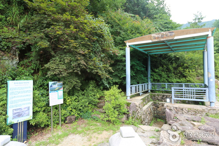
동면 후곡리 대암산 기슭에 자리잡고 있는 후곡약수터는 철분과 불소가 많이 들어있고 탄산가스가 풍부하여 위장병에 특효가 있으며, 피부병에도 효과가 있다고 알려져 있다.
도솔산 일대는 해안분지를 둘러싸고 있는 해발 1,148m의 험준한 산악 지대로 고지가 중첩 되어 있을 뿐 아니라 연중 이상기후가 계속되는 지대이며, 특히 여름에는 안개가 한치 앞을 분간하기 어려운 지역이다.
Punch Bowl is a basin formed at an altitude of 400~500m in Haean-myeon, Yanggu-gun, Gangwon-do, located about 22km northeast of Yanggu. Its shape resembles a punch bowl, hence the name 'Punch Bowl.' The elongated north-south terrain that narrows to the south has theories of meteorite impact and differential erosion; however, as there are no meteorite traces and due to erosion caused by differences in surrounding rocks, the differential erosion theory is more plausible. This basin is the only is a myeon-level area within the civilian access control line in Korea, centered on Daeam Mountain. It was a fierce battlefield during the Korean War with battles such as the Punch Bowl Battle, Dosolsan Battle, and Gachilbong Battle, and even now, memorials and mine warning signs remain throughout. After the war, civilians were restricted from entering, preserving nature well, allowing various rare flora and fauna such as the Korean trout, Gaeneusam, Geumgang Chorong, and Haerabinancho to inhabit the area. The 'Yongneup' at the summit of Daeam Mountain, at 1,300m altitude, is the only high moor in South Korea and is designated as Natural Monument No. 246. Within the basin, highland vegetables, potatoes, and lilies are cultivated. To the northwest, Eulji Observatory offers views of the 4th infiltration tunnel and Geumgangsan Birobong, serving also as a security education site. Visitors must apply for entry at the Yanggu Tongil Center.
제 4땅굴은 북한의 새로운 침투 방법으로 모색되어 굴설된 땅굴로 1978년 제3땅굴이 발견된 지 12년 만인 1990년 3월 3일에 양구 동북쪽 26㎞ 지점 비무장지대 안에서 발견되었으며 군사분계선에서 1.2km 떨어진 곳에 위치하고 있다. 그 규모는 높이와 폭이 각 1.7m, 깊이가 지하 145m이며, 총 길이는 2,052m로서 지난 1974년 고랑포 동북쪽 8km지점에서 발견된 제 1땅굴의 높이 1.2m, 폭 0.9m, 길이 지하 46m와 비교해 볼 수 있다.
Eulji Observatory is located on the ridge of Gachilbong, forming the Haean basin, 27 km northeast of Yanggu and 1 km south of the Military Demarcation Line. On December 12, 1987, the Federation of Korean Industries' chairman group visited the Army 1862 Unit and proposed the construction of a security education center. The following year, on May 31, 1988, 125 million won was donated to the unit, enabling the construction of Eulji Observatory. At an elevation of 1,049 m, this frontline security tourism site offers a panoramic view of Naegeumgang, including Geumgangsan Birobong, attracting about 100,000 visitors annually and playing an important role as a security education center. The observatory is a two-story concrete slab building with a height of 10 m and a floor area of 98 pyeong. Yanggu-gun completed paving 7 km of the military operation road leading to the observatory, and since February 1998, same-day visitor access has been allowed.
优先展示路线结束后方便休息的住宿
注册成为会员,让更多人认识你的频道。
(成为会员后,在“我的页面”中设置 Instagram、YouTube、博客链接,我们会在你发表的每条评论旁一起展示。)
““住在弘大附近,晚上去了一圈咖啡馆,城市夜景和氛围都太完美了。””
以访客身份发表的评论,不会显示任何社交账号链接或个人资料卡片
分享一条关于这个地点的小贴士吧。
或者以访客身份快速留下一个评论。
请登录后再上传照片。
还没有任何评论,快来写下你的第一条感受吧!