站在独岛上的乌陵岛 in 庆尚北道 郁陵县 · schedule 其他 · distance 39.4km · 3 stops · highlights 도동등대(행남등대), Bongnae Waterfall, Nari Basin
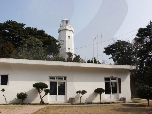
这里是乌陵岛旅行的起点。沿着道东港左右的海岸悬崖步道,可以看到撞击火山岩海壁的海浪和深海食洞下透明的海水。秋季时分,站在形成群落的毛蓼花盛开的行南灯塔上眺望大海。
这条路线是单日行程示例。你可以直接保存,或扩展为 AI 行程。
등대가 위치한 행남마을은 도동과 저동 사이의 해안을 끼고 있는 촌락으로 울릉도에서 가장 동쪽에 위치하고 있다. 겨울에도 살구꽃을 볼 수 있다는 따뜻한 마을로, 마을 어귀에 큰 살구나무가 한 그루 있었다하여 행남(杏南)으로 전래되고 있다. 또한 지형이 뱀의 입처럼 생겼다고 하여 살구남(口南)이라고도 한다. 청명한 날에는 등탑에서 정동쪽으로 독도를 볼 수 있으며, 북쪽으로는 저동항의 아름다운 모습과 촛대바위를 한 눈에 바라다 볼 수 있고, 울릉도의 상징인 성인봉의 정상을 볼 수 있다.
Bongnae Waterfall consists of three tiers. From the top, the first tier is composed of granodiorite and tuff, while the second and third tiers are made up of agglomerate. The total drop is about 30 meters, with a flow rate exceeding 3,000 tons per day, serving as an important water source for the southern Ulleungdo area. The waterfall's uppermost part is made of granodiorite, which is more resistant to erosion than tuff or agglomerate. Differential erosion due to strength differences between the rocks has formed multiple tiers of the waterfall. As the lower tuff and agglomerate erode further, the upper granodiorite will collapse, causing the waterfall to retreat gradually. A walking trail leads from the Bongnae Waterfall management office to the waterfall, featuring a wind cave called the "natural air conditioner" due to the cold wind, a dam built to prevent landslide damage, and a forest bathing area for alleviating atopic dermatitis and relieving stress. Various plant species such as island hepaticas (large hepaticas), wasabi mustard, yellow Impatiens, large yanyeongcho, island male fern (umbrella male fern), and royal crown (royal crown root), as well as tree species including beech, umbrella gorosoe, cedar, akebia, mapojumeu tree (mapojumeu tree), and hinoki cypress can be seen, making it an excellent geological site for both geology and ecological education.
Nari Basin is a caldera crater formed by the collapse of a volcanic crater following the eruption of highly viscous trachyte, andesite, and tuff during the late Tertiary period of the Cenozoic era. In the past, people had no livestock and ate the roots of the island lily, which gave rise to the place name Nari, and thus it was called Nari Basin. Its size is about 1.5 km in east-west width, 2 km in north-south length, and the area is 1.5 to 2.0 km². The basin is surrounded like a folding screen by mountains about 500m in elevation, with the highest peak, Seonginbong (984m), located to the south, and inside the basin is the conical central crater, Albong (611m). Nari Basin’s landform was created by the collapse of a crater north of Seonginbong during a volcanic eruption, covering an area roughly equivalent to 28 soccer fields. Due to its unique volcanic terrain, it is registered as a national geosite park, and walking trails and trekking courses have been established around Nari Basin. The most recommended course is the trail around Albong (538m) and Gitdaebong (579m). Given the island’s characteristics, there are Ulleung daisies and plants unique to Ulleungdo, allowing visitors to enjoy a forest landscape unlike anywhere on the mainland.
优先展示路线结束后方便休息的住宿
注册成为会员,让更多人认识你的频道。
(成为会员后,在“我的页面”中设置 Instagram、YouTube、博客链接,我们会在你发表的每条评论旁一起展示。)
““住在弘大附近,晚上去了一圈咖啡馆,城市夜景和氛围都太完美了。””
以访客身份发表的评论,不会显示任何社交账号链接或个人资料卡片
分享一条关于这个地点的小贴士吧。
或者以访客身份快速留下一个评论。
请登录后再上传照片。
还没有任何评论,快来写下你的第一条感受吧!