国土の正中で同族相残の悲劇に出会う in 江原特別自治道 両区郡 · schedule その他 · distance 62km · 5 stops · highlights 후곡약수터, 도솔산 해병대전투전적지, Yanggu Punch Bowl Village

大韓民国の領土を「朝鮮半島とその付属島嶼」と仮定すると、国土の正中に位置するのが楊口である。加七峰から見下ろす様子がまるで果物の盛り合わせの器に似ていることから名付けられたパンチボウルや、道率山海兵隊戦闘戦跡地など、朝鮮戦争当時に激しい戦闘が繰り広げられた傷跡の地である。国土の最果てで美しい自然とともに楽しめる安全保障旅行の最適地といえる。
このコースは1日旅程のサンプルです。そのまま保存するか、AI日程に拡張できます。
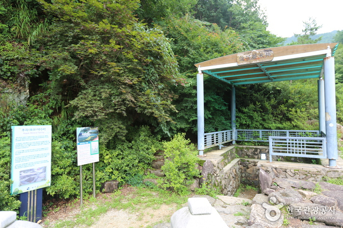
동면 후곡리 대암산 기슭에 자리잡고 있는 후곡약수터는 철분과 불소가 많이 들어있고 탄산가스가 풍부하여 위장병에 특효가 있으며, 피부병에도 효과가 있다고 알려져 있다.
도솔산 일대는 해안분지를 둘러싸고 있는 해발 1,148m의 험준한 산악 지대로 고지가 중첩 되어 있을 뿐 아니라 연중 이상기후가 계속되는 지대이며, 특히 여름에는 안개가 한치 앞을 분간하기 어려운 지역이다.
Punch Bowl is a basin formed at an altitude of 400~500m in Haean-myeon, Yanggu-gun, Gangwon-do, located about 22km northeast of Yanggu. Its shape resembles a punch bowl, hence the name 'Punch Bowl.' The elongated north-south terrain that narrows to the south has theories of meteorite impact and differential erosion; however, as there are no meteorite traces and due to erosion caused by differences in surrounding rocks, the differential erosion theory is more plausible. This basin is the only is a myeon-level area within the civilian access control line in Korea, centered on Daeam Mountain. It was a fierce battlefield during the Korean War with battles such as the Punch Bowl Battle, Dosolsan Battle, and Gachilbong Battle, and even now, memorials and mine warning signs remain throughout. After the war, civilians were restricted from entering, preserving nature well, allowing various rare flora and fauna such as the Korean trout, Gaeneusam, Geumgang Chorong, and Haerabinancho to inhabit the area. The 'Yongneup' at the summit of Daeam Mountain, at 1,300m altitude, is the only high moor in South Korea and is designated as Natural Monument No. 246. Within the basin, highland vegetables, potatoes, and lilies are cultivated. To the northwest, Eulji Observatory offers views of the 4th infiltration tunnel and Geumgangsan Birobong, serving also as a security education site. Visitors must apply for entry at the Yanggu Tongil Center.
제 4땅굴은 북한의 새로운 침투 방법으로 모색되어 굴설된 땅굴로 1978년 제3땅굴이 발견된 지 12년 만인 1990년 3월 3일에 양구 동북쪽 26㎞ 지점 비무장지대 안에서 발견되었으며 군사분계선에서 1.2km 떨어진 곳에 위치하고 있다. 그 규모는 높이와 폭이 각 1.7m, 깊이가 지하 145m이며, 총 길이는 2,052m로서 지난 1974년 고랑포 동북쪽 8km지점에서 발견된 제 1땅굴의 높이 1.2m, 폭 0.9m, 길이 지하 46m와 비교해 볼 수 있다.
Eulji Observatory is located on the ridge of Gachilbong, forming the Haean basin, 27 km northeast of Yanggu and 1 km south of the Military Demarcation Line. On December 12, 1987, the Federation of Korean Industries' chairman group visited the Army 1862 Unit and proposed the construction of a security education center. The following year, on May 31, 1988, 125 million won was donated to the unit, enabling the construction of Eulji Observatory. At an elevation of 1,049 m, this frontline security tourism site offers a panoramic view of Naegeumgang, including Geumgangsan Birobong, attracting about 100,000 visitors annually and playing an important role as a security education center. The observatory is a two-story concrete slab building with a height of 10 m and a floor area of 98 pyeong. Yanggu-gun completed paving 7 km of the military operation road leading to the observatory, and since February 1998, same-day visitor access has been allowed.
コース後に休みやすい宿を集めました
会員登録して自分のチャンネルも一緒に紹介してもらう
(会員になると、マイページで設定した Instagram・YouTube・ブログのリンクが、あなたのコメントと一緒に表示されます。)
“「弘大近くに滞在して、夜のカフェ巡りをしました。街の夜景も雰囲気も最高でした。」”
ゲストとして投稿したコメントには、SNSリンクやプロフィールカードは表示されません。
この場所についてのちょっとしたコツや感想をシェアしてください。
ゲストとして、気軽にひとことコメントを残すこともできます。
写真の添付はログイン後に利用できます。
まだレビューがありません。最初の感想を投稿してみましょう!