ウルジュ文化遺産コース2 in ウルサン広域市 ウルジュ郡 · schedule その他 · distance 120km · 3 stops · highlights Seoknamsa Valley, Ulsan 12 Scenic Views, Hobakso Valley
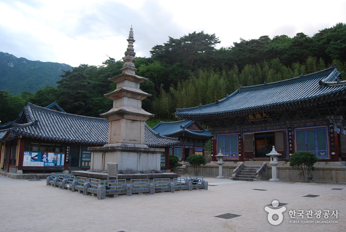
ウルソクナムサは新羅時代の古刹で、現在は30棟以上の建物がある大寺院である。この寺院をすべて見て回るには半日かかるだろう。夏には周辺のソクナムサ渓谷を訪れることができる。涼しく青い水が暑さを忘れさせる。カジサンの周囲の景観と調和したウルサン12景の中でも欠かせない名所である。
このコースは1日旅程のサンプルです。そのまま保存するか、AI日程に拡張できます。
Seoknamsa Valley is a valley surrounding Seoknamsa Temple located in Ulju-gun. Seoknamsa, situated on the eastern foothills of Gajisan, is an ancient Buddhist nunnery built on a hill at an elevation of 360m overlooking the clear waters of Neungdongcheon stream. The water flowing down from Unmunryeong and Neungdongcheon and Deokhyeoncheon towards Eonyang-eup is very clear. Although the valley is only about 1km long, large and small flat rocks provide excellent resting spots where visitors can dip their feet and cool off. Between the rocks are small waterfalls and shallow pools, and a dense forest alongside the valley offers shade from the midday summer sun. Passing through the temple’s Iljumun gate and going up the road to Seoknamsa, if you go further up along the right side through the forested area you can enjoy the flowing water of the valley and see the Seoknamsa temple buildings and the valley scenery in one view. Around here, by using the pedestrian path rather than the road to cross a bridge, you enter the temple grounds.
[Ulsan View 1: Taehwa River National Garden Shillidaebot] Korea's second national garden featuring a 4.3 km-long Shillidaebot bamboo forest, the largest in the country, creating beautiful scenery along both sides of the Taehwa River. [Ulsan View 2: Daewangam Park] A place with a legend that the memorial stone to King Munmu of Silla, who wished to become a guardian dragon of the East Sea after death, was submerged in this sea; it is the southeasternmost point jutting sharply into the East Sea. [Ulsan View 3: Gajisan Four Seasons] Gajisan Mountain (1,241m), highest in Yeongnam Alps, offers azaleas and rhododendrons in spring, clear valley water and greenery in summer, colorful autumn foliage, and beautiful snowy scenes in winter. [Ulsan View 4: Sinbulsan Silver Grass Plain] A wide, flat ridge about 3 km long between Gajisan and Ganwolsan reaching Yeongchuksan, with silver grass fields spreading across the autumn plain. [Ulsan View 5: Sunrise at Ganjeolgot] The earliest sunrise point on the East Coast, Ganjeolgot rises 1 minute earlier than Homigot in Pohang and about 5 minutes earlier than Jeongdongjin in Gangneung, attracting many tourists every January 1st. [Ulsan View 6: Bangudae Petroglyphs and Cheonjeon-ri Engravings] Bangudae Rock Carvings are important prehistoric relics depicting marine hunting culture; Cheonjeon-ri Engravings include various patterns such as sailing boats and inscriptions from the Silla period. [Ulsan View 7: Gangdong and Jujeon Pebble Beaches] Representative summer beach in Ulsan Dong-gu, located on the Gangdong-dong coast in Ulsan Buk-gu, composed of pebble stones. [Ulsan View 8: Ulsan Grand Park] The largest urban park in the country (3.69 million ㎡), providing a premium resting space and urban ecological park for citizens. [Ulsan View 9: Night View from Ulsan Bridge Observatory] A landmark offering views of Korea's longest single-span suspension bridge, Ulsan Bridge, as well as Ulsan's three major industrial complexes and seven famous mountains. [Ulsan View 10: Jangsaengpo Whale Culture Village] Korea's only whale special zone where you can see everything about whales, including a museum, ecological experience center, and the old look of Jangsaengpo Port. [Ulsan View 11: Oegosan Onggi Village] The nation's largest onggi (earthenware) village preserving ancestors' wisdom, with spaces to experience the making and uses of onggi. [Ulsan View 12: Daewunsan Naewonam Valley] Daewunsan Mountain, home to deep forests, clear valleys, and rock slabs, is known as Yeongnam's foremost auspicious site and houses Naewonam, where monk Wonhyo conducted his final training.
Located about 32 km from the center of Miryang city in Nammyung-ri Sirye Village of Sannae-myeon, there is the Ice Valley extending from Jaeyaksan (Cheonhwangsan), and about 3 km from here appears Hobakso Valley, a stream of Gajisan. Over hundreds of thousands of years, the valley water has washed white jade-like granite, creating white foam as it falls, and the surrounding natural scenery is so beautiful that it was selected as one of Korea's top 100 exquisite waters. According to Dongguk Yeoji Seungnam, Hobakso is a pond hollowed by a waterfall about 10 meters high and is called Hobakso because it looks like a type of mortar used in mills called hobak. Its circumference is about 30 meters, and it is also called Sirye Hobakso, Guyeon Waterfall, or Baekryeon Waterfall. Additionally, Hobakso was used as a rain prayer pond during long droughts. In the past, locals tried to measure the water depth by unspooling a thread of silk tied to a stone, but it was said they never reached the bottom, indicating great depth. This waterfall gorge with a white rock floor is an unpolluted area, with nearby Baekryeonsa Temple, Hyeongjeso, and five-thousand-pyeong flat rock, making the scenery very beautiful.
コース後に休みやすい宿を集めました
会員登録して自分のチャンネルも一緒に紹介してもらう
(会員になると、マイページで設定した Instagram・YouTube・ブログのリンクが、あなたのコメントと一緒に表示されます。)
“「弘大近くに滞在して、夜のカフェ巡りをしました。街の夜景も雰囲気も最高でした。」”
ゲストとして投稿したコメントには、SNSリンクやプロフィールカードは表示されません。
この場所についてのちょっとしたコツや感想をシェアしてください。
ゲストとして、気軽にひとことコメントを残すこともできます。
写真の添付はログイン後に利用できます。
まだレビューがありません。最初の感想を投稿してみましょう!


